As discussed earlier in this series, 2-8 London Road no longer exist — so while my schedule would suggest that today I should be writing about 4 London Road, instead I’m going to cover the genesis and initial years of West Croydon Station.
Croydon has a long association with railways. The Surrey Iron Railway, which opened on 26 July 1803 as the world’s first public railway,[1] ran from Wandsworth to Croydon via Mitcham. It was double-tracked for most of its eight-mile length, and carried goods such as iron, copper, bricks, coal, charcoal, oilseeds, and even dung, loaded into horse-drawn wagons on flanged rails.[2]
The Surrey Iron Railway initially ran to Pitlake Meadow, which no longer exists but was in the area where Reeves Corner is today.[3] The tracks did not pass through where West Croydon station now stands, but rather somewhat to the west, on the other side of what is now the Roman Way overpass.[4] However, following the opening of the Croydon Canal six years later, a short railway extension was built from Pitlake Meadow to connect with the canal at the site now occupied by West Croydon station.[5]

The decades following the opening of the Surrey Iron Railway saw a number of proposals for railway lines connecting London with Brighton, many (though not all) of them intended to pass through Croydon. Unlike the older railway, these lines were planned to carry passengers as well as freight, using steam locomotives instead of horsepower.[6]
At this time, any new railway line had to be authorised by an Act of Parliament. The first of the Croydon schemes to obtain such an Act, on 12 June 1835, was the London and Croydon Railway, which would run from London Bridge to what is now West Croydon Station. The London and Croydon Railway plans at this point no longer included running to Brighton; but following the passing of this Act, other railway companies submitted proposals to use part of the route for their own planned services to Brighton, splitting off just south of where Norwood Junction Station stands today.[7]
West Croydon Station opened on 5 June 1839 under the name of Croydon Station.[8] Trains ran from London Bridge over the route of the London and Greenwich Railway for the first 1¾ miles and then on new track following the route of the old Croydon Canal, which had closed in August 1836 in order to make room for the new railway. The intermediate stations may be familiar to those who travel via West Croydon today — they were at New Cross (now New Cross Gate), Dartmouth Arms (now Forest Hill), Sydenham, Penge (now Penge West), Annerley (now spelt Anerley), and Jolly Sailor (now Norwood Junction).[9]
It should be remembered that at this time, the land between London Bridge and Croydon was much less densely-populated than it is today; indeed, it was so unpopulated that two of the stations (Dartmouth Arms and Jolly Sailor) were named after pubs that had been built to serve the locks along the canal.[10] Maps of the period show only scattered settlements along the route; see for example William Faden’s 1800 “Topographical Map of the Country Twenty Miles Round London”. M W G Skinner’s “Croydon’s Railways” confirms this, noting that when the railway opened in 1839, “Between New Cross and Croydon there was more or less open countryside so the potential for traffic was not good. The intermediate stations were provided to serve the small communities and to give them a means of travelling from place to place.”
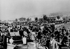
Regardless of this, the new railway was an instant success. It carried 11,000 people on its second day of operations, which coincided with the annual Croydon Fair.[11] A decade later, Daw’s 1849 Directory of Croydon described it thus: “[the] railway from the town to the foot of London-bridge [...] is said to be one of the best formed lines of this description hitherto constructed, and has been the medium of greatly augmenting the number of visiters [sic] to this pleasant district, celebrated for the beautiful views that may be enjoyed, and for the salubrity of the air, considered so peculiarly beneficial to invalids.”[12]
On 29 July 1844, an Act of Parliament was passed stating that “the making of a Railway, to commence by a Junction from the London and Croydon Railway at Croydon in the County of Surrey, and to terminate at Epsom in the same County, would be of great public Advantage, by opening a more easy and expeditious Communication than now subsists between those Places and between Epsom and the Metropolis”.[13] This extension opened in May 1847 and connected West Croydon Station (which at that point was called Croydon Town Station[8]) to Epsom, initially running 10 trains each way on weekdays and 6 on Sundays. New through platforms were constructed to accommodate this, as previously all trains had been terminating ones. On Derby Day of the same year, the new line carried a total of 32,000 passengers, and by the turn of the century the weekday service frequency had increased to 26 down (away from London) and 24 up (towards London).[14]
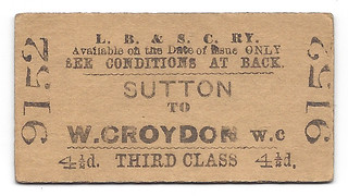

Another extension opened in October 1855, running from West Croydon to Wimbledon, partly along the old route taken by the Surrey Iron Railway in its journey to Wandsworth via Mitcham.[15] Unlike the Epsom extension, this was not a through service; the Wimbledon trains started and terminated at West Croydon (which by then was in fact finally actually called West Croydon[8]). A new terminating platform was added to accommodate this.[16] The Wimbledon branch initially ran only 6 trains per weekday and 2 on Sundays; by the turn of the century these frequencies had increased only slightly, to 10 or 12 trains per day as of 1910.[17]
As mentioned above, when the station first opened it was called not West Croydon Station but Croydon Station, and the name remained the same until 1847 at which point it changed to Croydon Town Station. East Croydon station also opened as “Croydon Station”, in 1841, and according to Skinner it’s unclear when the name officially changed to East Croydon. So between 1841 and 1847 there seem to have been two stations both named “Croydon”, just ten minutes’ walk apart; one wonders if this was confusing to the residents at the time.[18]
Another difference from the present day is that the station entrances in the 1800s were not where they are today. As noted above, when the station first opened, the only service was a terminating one from London Bridge; hence only one entrance (and platform) was needed. This entrance was on the London Road side, though set somewhat further back than the current London Road entrance and also slightly to the north of it; today, the location of this entrance is basically the back of the car park. Old drawings show this as looking fairly grand, which fits well with the importance it would have had for the town.
After the through services to Epsom commenced in 1847, a new entrance was opened on Station Road.[19] This one was quite near the current Station Road entrance; in fact, the old station buildings on this side are still standing, though today they’re occupied by Supreme Motor Spares.

The current London Road entrance wasn’t constructed until the 1930s, and the current Station Road entrance didn’t put in an appearance until 2012 (though there was a second Station Road entrance in between, in a different location again) — but more of that in a later article.
Thanks to: Peter Clark for fact-checking and additional information; Mark Justice for the loan of railway books; all at the Croydon Local Studies Library; and my beta-readers bob, Flash, Kat, Shuri, and Steve.
Footnotes and references
- According to Vic Mitchell and Keith Smith’s Mitcham Junction Lines (Middleton Press), although other rail systems existed at the time, these were all associated with specific industries rather than being open for public use.
- Details of the opening date, goods, rails, and wagons taken from Surrey Railways Remembered by Leslie Oppitz and Croydon’s Railways by M W G Skinner. Note the difference with today’s railways — the Surrey Iron Railway used flangeless wheels and flanged rails, while today it’s the wheels that are flanged. According to Charles G Harper’s The Brighton Road, the reason for putting the flanges on the rails was that it allowed the wagons to travel on ordinary roads if necessary (p122). A section of these flanged rails, from the 1805 extension to Merstham, can still be seen in Rotary Fields in Purley.
- Skinner says the Surrey Iron Railway “started at Ram Field (by the Ram Brewery) in Wandsworth and ran via Mitcham to Pitlake Meadow (near Croydon Parish Church [i.e. Croydon Minster])”. I should note that despite having spent a fair amount of time staring at old maps, I don’t remember ever seeing one with Pitlake Meadow marked on it, so I’m not sure how widely-used this name was. Oppitz identifies the Croydon terminus as Reeves Corner (though it wasn’t actually called Reeves Corner at this point — the Reeves furniture store wasn’t founded until over half a century later).
- More information about the route (and other aspects) of the Surrey Iron Railway is available on the Wandle Industrial Museum website.
- According to Skinner, the Croydon Canal opened on 23 October 1809 and connected Croydon to the Grand Surrey Canal via a junction just north of New Cross (thus providing a link to the Thames at Rotherhithe). It was not a great success, and only lasted until 22 August 1836, when it closed in order that the canal bed could be used for the London and Croydon Railway. (For more on the Grand Surrey Canal, see Andie Byrnes’ article.)
- More details of the London-to-Brighton proposals are provided in Skinner’s book. As an aside, Oppitz notes that “[t]here is no evidence of passenger services on the Iron Railway on a regular basis but it is quite possible that waggons were cleaned out and sometimes used for excursions or organised outings.”
- Before nationalisation on 1st January 1948, all railways in the UK were built and run by private companies. These companies had no general powers of compulsory land purchase, so each time they wanted to build a new line, they had to apply to parliament for an Act to authorise them with such power for the land along the route (Peter Clark, personal communication, 2012; see also overview of Private Acts on the UK Parliament website). All other information in this paragraph taken from Skinner, who should be consulted for more details.
- Vic Mitchell and Keith Smith’s West Croydon to Epsom (Middleton Press) says that West Croydon was initially named Croydon, became Croydon Town in May 1847, and West Croydon in April 1851 (though I should note that Croydon’s Transport Through the Ages [CNHSS, ed. John Gent] claims [on p20] that it was called Croydon all the way until 1851).
- Route and station information taken from Skinner. C F Dendy Marshall and R W Kidner’s History of the Southern Railway gives the further detail that when the London and Croydon Railway company bought the Croydon Canal, they paid “£40,250 for the property, and one shilling in respect of profits”. The route of the canal can be seen on a Google Map created by Will Greenwood, which shows clearly how closely it’s followed by the train tracks.
- Information on the reason for these pubs being built was supplied by Peter Clark. The Dartmouth Arms and Jolly Sailor still exist today, though both were rebuilt in the 1860s (See historical info on the Dartmouth Arms website and the Pubology entry for the Jolly Sailor, respectively).
- Information on passenger numbers and Croydon Fair taken from Skinner. Grace’s Guide notes further that one-way fares as of 1840 ranged from 1s 3d to 1s 9d, though they don’t make it clear whether these are different-class fares for the same route, or same-class fares for different parts of the route.
- Daw’s 1849 directory consulted at the Croydon Local Studies Library.
- 1844 Act consulted at the Croydon Local Studies Library; shelfmark S70 (385) PAR.
- Information on train frequencies taken from Mitchell and Smith’s West Croydon to Epsom. Derby Day passenger numbers taken from Skinner. Information on platforms extrapolated from Mitchell and Smith’s Mitcham Junction Lines, which states in the caption to photo 117 that “through platforms were added for the Epsom service prior to its commencment [sic] on 10th May 1847.”
- According to Mitchell and Smith’s Mitcham Junction Lines, the Surrey Iron Railway closed on 31 August 1846 and the West Croydon to Wimbledon extension opened on 22 October 1855. It’s worth noting that there was further re-use after the West Croydon to Wimbledon service ceased in May 1997 — it’s now used by Tramlink.
- Photographs of this bay platform, which is no longer in existence, can be seen in Mitchell and Smith’s “Mitcham Junction Lines” (photo 117) and John C Gillham’s “Wimbledon to Beckenham” (photos 68 and 69). The Local Studies Library also have relevant photos, notably PH-07 1653 from March 1967. The bay platform was inset into the Epsom end of the current platform 3; Peter Clark locates it where the dot matrix banner repeater signal is today. See also my photo of some suggestive brickwork along the side of the platform today.
- Train frequencies taken from Gillham, who also notes that services continued to gradually increase over the years until by 1930 the weekday service was half-hourly and the Sunday service hourly (it isn’t entirely clear if he’s counting Saturdays as weekdays, though he probably is).
- Peter Clark notes that at this period both stations were controlled by the same company (the London, Brighton and South Coast Railway), so it’s even more surprising that the naming confusion persisted for so long.
- I don’t know exactly when the first Station Road entrance opened; my claim that it happened after the Epsom extension opened is mostly conjecture, though a commenter on the London Reconnections site also states that it wasn’t there before 1847, and Figure 31 in Croydon’s Transport (which can be viewed online as a PDF at the archived version of the London Reconnections site) dates it to c.1860.