As explained earlier in this series, numbers 2, 4, 6, and 8 London Road no longer exist — so instead of writing about 8 London Road, here I present the final instalment of my research into West Croydon Station, covering developments in the 2000s and looking at the role of the station within the area today.
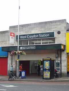
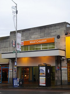
To recap briefly, West Croydon Station opened in 1839 as Croydon’s first railway station. Services initially ran from London Bridge and terminated here, but an extension was opened to Epsom in 1847 and another to Wimbledon in 1855. The station was rebuilt in the early 1930s to create the more prominent London Road façade that still stands today. Along with the rest of Britain’s railways, it was nationalised in the 1940s and re-privatised in the mid-1990s. (Further details of these developments can be found in my two previous articles on the subject, linked above.)
While East Croydon is now usually considered a more important station than West Croydon, this has not always been the case. As noted above, West Croydon was the first to open, in 1839, with East Croydon following in 1841. Gray & Warren’s 1859 Directory of Croydon has a long paragraph on “The Railway Stations” of Croydon, devoting 13 lines to West Croydon station and only 5 to East Croydon (it does concede, however, that East Croydon was “one of the most important establishments on the Brighton and Dover Railways”).[1] The October 1932 issue of Southern Railway Magazine gives comparable figures for the annual “number of passengers booked” at both West Croydon (1,001,075) and East Croydon (1,304,377), though East Croydon does win on season tickets (19,740 vs. 5,607).[2]
Even today, according to the draft Croydon Opportunity Area Planning Framework published in July 2012, “more people arrive at West Croydon during the day to go shopping than at East Croydon”.[3] This perhaps isn’t too surprising, given the two stations’ relative proximities to the main shopping area of North End; from the main entrance of West Croydon Station to the front door of the nearest major store (Marks & Spencer) is just over 100 metres, whereas the distance from East Croydon Station to the closest part of North End is six times greater.
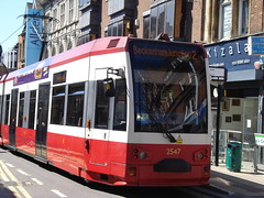
Of Croydon’s major transport developments in the 2000s, the first one relevant to West Croydon Station was the creation of Tramlink in summer 2000.[4] Trams don’t run directly from the station itself — the tram stop is opposite the bus station on Station Road, around the corner from the main station entrance.[5] However, the connection is a very useful one for onward travel, both within the Croydon area and further afield to places like Wimbledon, Elmers End, and New Addington.

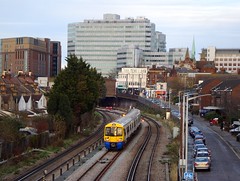
Another major development was the extension of the East London Line to West Croydon. Previously a Tube line running from Shoreditch Station in the north to New Cross Station and New Cross Gate Station in the south, the East London Line was transferred to London Overground[6] and redeveloped and extended during 2008-2010. Full service from Dalston Junction via New Cross Gate through to West Croydon began on 23 May 2010,[7] and this first phase of redevelopment was completed in February 2011, when the service began running beyond Dalston Junction to Highbury & Islington.[8]
Although London Overground trains terminate at West Croydon, they do so at a through platform, Platform 4. There are two plausible reasons for this, though I have no official confirmation of either. First, it’s more convenient for passengers who want to continue their journey southwards, as it gives them a same-platform interchange with trains down to Sutton and Epsom. Second, West Croydon only has one terminating platform, Platform 1, which is already used by the London Bridge service (and sometimes also by Victoria-bound trains).[9] Hence, after passengers have disembarked at Platform 4, London Overground trains continue a little way down the track and pause for several minutes just short of the Roman Way overpass (shown below), before coming back to the station to pick up northbound passengers.[10]
While planning this article, I received a request from a reader who asked me to explain “why the Overground always seems to take ages to get into West Croydon.” It’s a fair question! Passengers who frequently travel into the station will be well aware that there’s often a long pause between Norwood Junction and West Croydon, with the train sitting still for a few minutes and no announcement from the driver.
The reason for this is that there are several railway lines that cross at this point (known variously as the Windmill Bridge Junction or the Selhurst Junction), with all trains going north out of Croydon having to fit through. The lines from West Croydon and East Croydon split here into track going to Victoria and to London Bridge, and there’s also a split into fast and slow lines to both of the latter destinations. Hence trains often have to wait for other trains to get out of the way. Network Rail’s Strategic Business Plan for 2014–2019 (PDF) identifies this junction as one of the key capacity constraints on the Sussex Route: “11 conflicting routes caused by flat junctions and longer trains”, though as far as I can tell it contains no plans to alleviate this, mentioning only a vague hope that resignalling further south at Three Bridges will allow improvements at Windmill Bridge in the future.[11]

London Overground is of course not the only train operator to run services from West Croydon Station. Services to Victoria and London Bridge have been provided by Southern since August 2001.[12] These are mainly stopping (i.e. slow) services, though there are a few fast services to and from London Bridge each day.[13]
As mentioned above, until very recently the route from the rail platforms to the tram stop and bus station on Station Road was a rather convoluted one,[14] requiring a fairly long walk from the main station entrance around the corner and down Station Road — not exactly the model of an integrated transport system! However, this all changed in late 2012 when a new entrance was opened on Station Road, connecting Platform 4 directly to the pavement beside the tram stop.[15] Although perhaps more useful as an exit than an entrance (Platform 4 serves only a few destinations down towards Sutton and Epsom), it’s very handy both for those who wish to continue their journey via tram or bus, and for those who fancy popping in to the Station Road shops on the way home.[16]
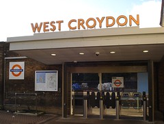
During discussions at the West Croydon Community Forum (of which I am a member), the importance of West Croydon Station as a “gateway” to London Road comes up over and over again.[17] Indeed, the station’s importance to the area has remained high over the 174 years since it was built (its name is almost certainly the main reason that the area is known as West Croydon rather than the more geographically accurate North Croydon[18]). As West Croydon moves into the future, with regeneration planned both as post-riot reconstruction and as part of the West Croydon Masterplan, its station is likely to play a key part.
Thanks to: Paul Sowan for fact-checking and additional information; all at the Croydon Local Studies Library; and my beta-readers bob, David, Flash, Kat, and Shuri.
Footnotes and references
- This paragraph appears on page xxi of Gray & Warren’s 1859 Directory of Croydon.
- These figures appear on p383 of the October 1932 issue of Southern Railway Magazine (consulted at the Croydon Local Studies Library) as part of an article by L Catchpole, “The Railways of Croydon”. Paul Sowan notes that the lower number of season tickets sold at West Croydon is likely connected to the fact that this station was more focused on short journeys, in contrast to its counterpart in the East.
- The Opportunity Area Planning Framework (OAPF) is available on the Croydon Council website; the part I quote is in section 7.27 of the PDF containing chapters 5–9, numbered as p79. The original source is stated as “NRTS”, which isn’t spelled out anywhere in the document — I think it’s the National Rail Travel Survey, though I’m not sure from which year. (When I originally wrote this article, my source was the July 2012 draft of the OAPF; the link above goes to the final version, which has now been published.)
- More information about Tramlink can be found on the ever-excellent London Reconnections site: part 1, part 2. It’s also worth noting another connection between Tramlink and West Croydon Station: a substantial amount of the Tramlink route between West Croydon and Wimbledon follows the same route used for the train service that ran between these two stations from 1855 to 1997, and before that formed part of the route of the Surrey Iron Railway (see my article on West Croydon Station in the 1800s).
- Compare this with the situation at Mitcham Junction and at Wimbledon, where the tram stops are much more integrated with the railway stationpened in 2012.
- London Overground is also a part of Transport for London (TfL). It’s perhaps worth noting that the term “East London Line” isn’t actually used by TfL, but it’s commonly used by the public.
- There was also a restricted preview service between Dalston Junction and New Cross/New Cross Gate, which began on 27 April 2010.
- The second phase of East London Line redevelopment was completed in December 2012 with the opening of a branch from Surrey Quays to Clapham Junction. However, the only effect this had on services from West Croydon was sadly a negative one. Trains on this branch are scheduled to run all the way between Clapham Junction and Highbury & Islington, and hence some changes had to be made to ensure there was enough capacity on the track. West Croydon’s London Overground service to Highbury & Islington was one casualty of this, and our trains now run only as far as Dalston Junction, though the frequency of the service remains unchanged at 4 trains per hour.
- As an aside, here's a photo of an East London Line train at Platform 1 during engineering work last year.
- This information comes from personal observation, i.e. I can see them do it from my bedroom window.
- Here's a direct link to the PDF of the relevant section of the plan (i.e. that for the Sussex Route; document ref SBPT216, version 1.0). The quotation about the 11 conflicting routes is on p34, and the mention of possible future improvements is on p42. Although there are mentions of track and signalling refurbishments at Windmill Bridge on pages 61 and 66, I think these are mainly intended to stop things getting worse, rather than to make them any better.
- Following the 1996 re-privatisation of the railways, these services were operated by Connex; Southern took over in August 2001. It should be noted that the present-day Southern (which is a subsidiary of Govia) has no connection to the historic pre-nationalisation Southern Railway.
- As of January 2013, the fast services from West Croydon to London Bridge depart weekdays at 0615, 0644, 0714, 0744, 0815, 0844, 1712, 1742, and 1812. Morning services take 18–21 minutes and stop at Norwood Junction only; evening services take 16–18 minutes and are non-stopping. The fast services in the other direction depart London Bridge weekdays at 1703, 1729, 1802, 1832, and 1930; these take 18 minutes to get to West Croydon and stop at Norwood Junction only. By comparison, the regular weekday stopping services usually take around 40 minutes. To my knowledge, there are no fast trains on weekends, and no fast trains at all between West Croydon and Victoria (though some are less slow than others, i.e. 29–30 minutes vs. 38 minutes). Source: manual search through traintimes.org.uk for a selected Thursday, Saturday, and Sunday with no planned engineering works.
- Though a friend of mine has pointed out that one could occasionally persuade the staff on Platform 4 to let one out of the door in the wall there.
- Note that this is basically in the same place as the first ever Station Road entrance, which opened in the mid-1800s and closed in the early 1930s.
- I personally recommend both Finger Licking (a Ghanaian restaurant from which I have taken away many many takeaways) and Solnishko (a Russian delicatessen with a good stock of interesting bread).
- One joking suggestion for how we could get people to turn right instead of left on exiting the station, in order to draw their attention to London Road, was to “build a wall across the pavement”...
- The parliamentary constituency is Croydon North, and some people did start using this as a name for the area around the time of the 2012 by-election, but this seems to have died down again now. The name “North Croydon” is used occasionally, but a Google search for “West Croydon” returns ten times as many results as a search for “North Croydon”, and a search of the London Gazette archives (which stretch back to the early 1800s) reveals that “West Croydon” occurs 40 times as often as “North Croydon”. The earliest mention of “North Croydon” as an area name in the London Gazette is on page 1091 of the 27 February 1863 edition in relation to an address on Sydenham Road.
Comments
Thanks for the input! It’s always interesting to hear people’s views of what different areas are called. (Whitehorse Road definitely doesn’t run straight north-south though — it’s about 20 degrees off, same as London Road, though tilted in the opposite direction.)
The area now known as West Croydon wasn’t considered to be part of Croydon at all until relatively recently. North End was the actual northern end of Croydon (hence the name), and the area around the junction of London Road and St James’s Road was a separate settlement known as Broad Green. Infilling between Croydon and Broad Green took quite some time to get started even after the coming of the railway.
West Croydon Station and East Croydon Station were built by different railway companies, and both were originally just called Croydon Station; but after these two companies merged, the stations were renamed to their current names in order to avoid confusion. At that point, the land alongside London Road was still mostly undeveloped, and so West Croydon Station would still have marked the northern end of Croydon. Railway stations do tend to have a strong impact on what people call the area around them, so it’s not surprising that the new developments along London Road to the north of Croydon came to be called West Croydon instead of North Croydon.