Royal Parade, which spans from 206 to 272 London Road, was built in the early years of the 20th century on land which had previously been part of a large estate surrounding a house known as Broad Green Place. By the time its final owner died in 1899, this estate occupied the vast majority of the land between present-day London Road, St James’s Road, and Kidderminster Road, the only exceptions being a row of cottages along the western end of St James’s Road and the beginnings of housing development towards the western end of Kidderminster Road.
However, by the end of 1900 the house had been pulled down and two new roads called Nova Road and Hathaway Road had been laid through the grounds, ready for housing development. Later articles will discuss the individual properties in Royal Parade, but here I describe the history of Broad Green Place up to the point when the estate was sold off and Royal Parade — along with two hundred other houses — was built.

1700s: The estate in the 18th century
The house later known as Broad Green Place was likely constructed during the first half of the 18th century. A document from 1758 describes it as “a certain large New Built Mansion House [...] with appts and about 4 acres thereto belonging”, and refers to a mortgage taken out on it in December 1751. The occupant at the time of the 1758 document was John Butler, though he seems to have sublet it from a leaseholder, Benjamin Harding, who in turn leased it from the owner, Joseph Willoughby.[1]
In line with this, John Rocque’s 1768 map of Surrey shows the area bounded by the present-day London Road, St James’s Road, Wellesley Road, and Poplar Walk to be already enclosed and under cultivation. This stands in contrast to Parson’s Mead on the other side of London Road and Croydon Common further to the east, which were still common land.
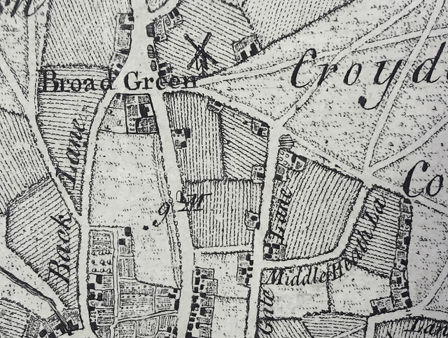
Rocque’s depiction of this area as three fields with five groups of buildings around the edges is almost certainly an approximation to the true situation, but not an entirely inaccurate one. As historian William Ravenhill states, “field boundaries [on Rocque’s map...] were hardly likely to have been accurately surveyed but they were probably sketched in by eye from vantage points along the surveyed roads.”[2]
A clearer (albeit later) picture can be gained from the 1800 Inclosure map, which was drawn up to accompany the division of Croydon Common and other common spaces into sections of private land, each allocated to a private owner. The three fields of Rocque’s map appear here as six irregularly-shaped plots owned by John Brookes, Elizabeth Panton, Richard Carew, John Gribble, John Young, and Robert Harris, plus smaller parcels of land which according to the Inclosure Award were sold or allocated to persons including John, Elizabeth, and “the Inhabitants of the Parish of Croydon”.[3]
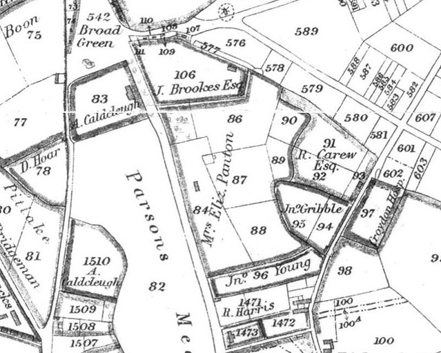
As shown on the map above, at the time of the Inclosure Award much of the land later known as the Broad Green Place estate was already in the possession of John Brookes. The Award Commissioners then sold or allocated John three adjoining plots which became part of the estate, increasing its size by more than three acres.[5]
Born around 1740, John came to Croydon from “Black’s Field in the Borough of Southwark”, where he had worked as a cooper. He married Mary Ruse of Croydon on 28 October 1773. Mary appears to have initially moved to Southwark to live with John, rather than his moving to Croydon to live with her, as according to a later census their daughter Mary was born in Southwark a couple of years after the marriage.[6] However, John was definitely living at Broad Green by 1793, as a legal document drawn up in that year describes him as being both owner and occupier of the estate.[7]
1800s: The estate in the 19th century
On 2 November 1800, Mary Brookes the younger married James Cox at Croydon Parish Church (now Croydon Minster). As John’s only child, she stood to inherit a substantial amount of property; not just the Broad Green Place estate, but also a share of a “part freehold and part leasehold” estate in Southwark and possibly other land elsewhere in Croydon.[9]
However, it was another 35 years before this inheritance came due, as her father John survived to the age of 94. He died at home on 9 April 1835 and was buried in his old parish of Southwark St John Horsleydown.[10]
John did not leave his estate directly to Mary. Indeed, at this time the law of England forbade married women from owning property; anything brought into the marriage or obtained during it would pass straight to their husbands. There were various ways around this, including placing assets into trust for the woman’s “sole and separate use”, but John took a simpler route. His will, made on 10 March 1834, stated that everything (aside from one relatively small personal bequest) would go to:[11]
“such person or persons for such Estate or Estates and in such manner as my daughter and only child Mary the wife of James Cox Esquire shall at any time or times notwithstanding any Coverture by any deed or deeds or by her will direct appoint give or bequeath the same.”
In other words, John left all his wealth and property to whoever Mary said should get it. He put no limits on how long she had to decide; indeed, he included an explicit provision that she could make the decision via a direction in her will.[12]
It seems to have been around 15 years after John’s death that the estate acquired the name of Broad Green Place. Prior to this, it may well simply have been called something along the lines of “the Brookes estate”; certainly the 1847 Roberts map labels the house itself as “Brook House”, and the 1850 Croydon & Reigate Directory lists James Cox as living at “Brook House, Broad-green”. However, Gray’s 1851 directory names James’ home as Broad Green Place, as do all subsequent directories up to and following James’ own death on 7 January 1862 at the age of 87.[14]
Mary survived her husband by half a decade, dying on 15 May 1867 at the age of 91. Her will left “all that messuage or tenement in which I now reside and the outhouses gardens land and hereditaments thereto belonging situate at Broad Green in the Parish of Croydon” to her daughters, Eliza Cox and Mary Brookes Cox, “for their own sole and separate use and benefit as tenants in common”. Thus the provisions of John Brookes’ will were finally put into practice, and Broad Green Place passed into the ownership of his granddaughters.[15]
1899: The death of Eliza Cox and the sale of the estate
Eliza Cox was both the final owner and the final occupant of the estate. She never married, and lived here with her sister Mary (who also never married) until the latter’s death on 14 July 1884 at the age of 79. Eliza herself survived to the same age as her mother, with her death on 5 March 1899 coming just over five weeks after her 91st birthday. She left a substantial estate, valued at £79,294 3s 6d (£10 million in 2018 prices).[16]
Less than six weeks later, Eliza’s “horses, carriages, live and dead stock” and other effects including carriage harnesses, iron troughs, ladders, “grindstone, hay forks and rakes”, and even “a part stack of meadow hay” had been put up for auction, and local pundits were pronouncing on the likely fate of her land:[17]
“The recent visit of the Pale Messenger to Broad Green will no doubt lead to a lot more land being thrown into the market for building. Not that the London-road is not already being altered out of all knowledge. It just is. If you haven’t been down that way lately I would recommend a constitutional down that road — on any but Sunday morning mind you — and you will be simply astonished. Private houses and shops are springing up all round, and not only building but letting easy.”
Hope was also expressed for a different outcome, with a local rumour claiming that “the cricket authorities at Kennington Oval” had the right of refusal to purchase “the fine large meadow” that formed part of Eliza’s estate. However, dreams of “seeing county cricket on Cox’s field at Broad Green” came to nothing, as on 26 June 1889 the entire estate was sold at auction for £30,500 (£3.8 million in 2018 prices).[18]
1900: The end of Broad Green Place
In advertising the estate, auctioneers Robert W Fuller, Moon, and Fuller had emphasised its “exceptional advantages for development”:[19]
“Especial attention is called to the fact that this is practically the only remaining vacant building land adjacent to this rapidly growing borough town with its eight stations, unrivalled railway facilities, and modern sanitary improvements, rendering it one of the healthiest large towns in the Kingdom. [...] a total available building frontage of 3,500 feet [just over 1km] could be formed at a small cost, thus affording an excellent opportunity for creating ground rents.”
Indeed, in April 1900 a nearby plot of building land was advertised “for the erection of an Hotel or Public-house” using the inducement that it was “situated immediately opposite the Broad Green Place Estate, upon which it is proposed to erect about 300 houses”.[20] By the end of the year, two new roads — Nova Road and Hathaway Road — had been laid out in the grounds of the estate, ready for the new housing.[21]
It’s unclear whether the purchaser of the estate ever considered retaining Broad Green Place as one of these houses, as had been the case when the Broad Green House estate across the road was broken up for sale a decade before. While new roads and housing sprang up all over its grounds, Broad Green House itself survived until the 1960s.
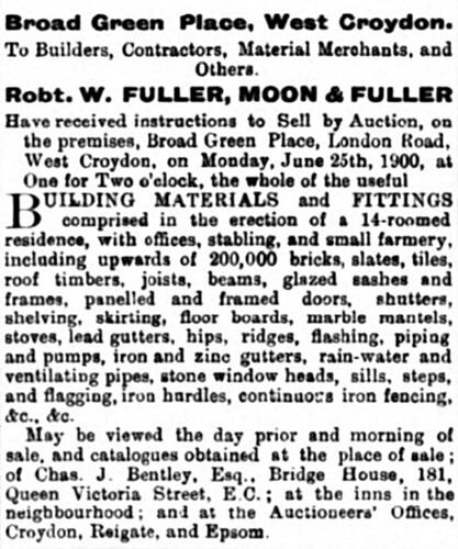
However, if this did ever come under consideration in the case of Broad Green Place, the consideration must have been very brief. By June 1900 the house had been pulled down and all the pieces put up for auction, including “upwards of 200,000 bricks, slates, tiles, roof timbers, joists, beams, glazed sashes and frames, panelled and framed doors, shutters, shelving, skirting, floor boards, marble mantels, stoves, lead gutters” and more.[22]
1900s: Royal Parade and Royal Mansions
On 18 July 1901, Mr A H Batley deposited plans with the County Borough of Croydon for “26 Houses & Shops” to be known as Royal Parade.[23] The architect in charge was Horace Thomas Bonner of Lewisham.[24] Stretching along the London Road frontage of the Broad Green Place estate from its southern edge to the junction with St James’s Road, the parade was designed with “a riot of architectural detail topped by numerous gables and domes”.
Interspersed with the shops along the ground floor were entrances to the flats above — and, unusually, each flat also had a back entrance accessed via the alleyways behind. The shops were given the addresses of 1–26 Royal Parade, while the flats were known as Royal Mansions.[25]
Building seems to have been substantially complete by August 1902, as adverts appeared in local newspapers offering the scaffolding for sale.[26]
The following month, Croydon County Borough Council found itself discussing a recommendation from its Roads Committee that the footway in front of the parade should “be made up with Val de Travers asphalte [sic] at the estimated cost of £252 [£30,426 in 2018 prices]”. This recommendation did not go unchallenged, as Councillor Stranks “wished to know whether the owners of the Royal Parade [...] ought not to bear a proportion of the cost”, but in the end the Council agreed to follow the Committee’s recommendation.[27]

At least 16 of the 26 new shops were occupied by the end of 1902; and at the close of the decade, the parade was home to a variety of businesses including a bakery, a china and glass dealer, a photography studio, a boot shop, two banks, a laundry depot, a tobacconist, a hairdresser, a greengrocer, and a butcher. All their individual stories will be told in future articles.[28]

Thanks to: Brenda Hawkins and James Coupe, for helpful discussion regarding John Brookes’ will; Lis Watkins; the staff in the Maps room at the British Library; the staff at Lambeth Palace Library; the Planning Technical Support Team at Croydon Council; the staff, volunteers, and patrons at the Museum of Croydon; and my beta-readers Kat and Rowley. Monetary conversions performed using the Bank of England inflation calculator (prices < £100 given to the nearest penny, prices from £100 to < £100,000 to the nearest pound, prices from £100,000 to < £1 million to the nearest £1,000, prices from £1 million to < £100 million to the nearest £100,000, prices ≥ £100 million to the nearest million).
Footnotes and references
Information and quotation taken from C G Paget’s transcription of the record of a Chancery inquisition into “lunacy” held on 2 August 1758 (pages 64–65 of Paget’s notebook 17). (Note that I haven’t seen the original of this, just Paget’s transcription. The National Archives catalogue record, ref C211/27/W76, gives Mr Willoughby’s name as “Joshua” rather than “Joseph”, but Paget is consistent in writing “Joseph”, so I suspect the error is in the catalogue rather than the transcription.) This document also states that Benjamin Harding’s lease would have “3 years to come at Lady day next”; that is, as of 25 March 1759 the lease would have three years left to run, and hence would expire in 1762. The person claimed to be “of unsound mind & not capable to govern his affairs” was Joseph Willoughby himself.
The 1758 document states the location of the house and land in question somewhat vaguely — “situated at or near a Place called Broad Green in the parish of Croydon” — but it also mentions “4 small cottages or dwellings thereunto adjoining now in the several occupations of Soloman Smith, Thomas Thornton, James Crosswell, & George Strong”. The 1800 Inclosure map (see excerpt in main article) shows these four cottages as plots 108, 109, 110, and 111; and plot 107, which is next to 108, is described in the Inclosure Award as “that parcel of freehold land near Broad Green on Croydon Common consisting of a barn and encroachment containing nineteen perches bounded on the north by the road, on the west by a garden belonging to James Crosswell, on the east by land sold to John Brookes, and on the south by the inclosures of the said J. Brookes”. This makes it clear that Joseph’s estate was in fact the estate later occupied by John Brookes. (I checked all this myself, but I have Aileen Turner’s unpublished History of Broad Green [p. 499] to thank for putting me onto the cottages connection in the first place.)
I worked out the boundaries in terms of modern roads by comparing Roque’s 1768 map to the 1800 Inclosure map, which as can be seen in part 1 of my mini-series on Zodiac Court lines up quite nicely with the modern road layout. My attempts at a similar superposition of Rocque’s map over the Inclosure map and of the modern road layout over Rocque’s map were much less satisfyingly neat. However, the Broad Green triangle and the routes of London Road, St James’s Road, Sydenham Road (“Middle Heath La[ne]”) and Wellesley Road (“New Gate Lane”) are clearly shown on Rocque’s map. The line of Wellesley Road is much straighter on Rocque’s map than on the Inclosure map; I suspect this to be an error of surveying rather than an actual change.
Quotation from William Ravenhill is taken from his introduction to Two Hundred and Fifty Years of Map-Making in the County of Surrey: a Collection of Reproductions of Printed Maps Published Between the Years 1579-1823 with Introductory Notes by William Ravenhill (Harry Margary, 1974), which includes a reproduction of Rocque’s map. Ravenhill adds that “Much of this detail [field boundaries and land use] was new to county mapping, but close local inspection in one small area has revealed a lack of authenticity in the field boundaries and comparison with earlier manorial maps would suggest that the number of fields needs to be increased before the field pattern would bear a close relationship to contemporary reality.” This appears to also hold in the area of present interest.
1800 Inclosure map viewed as a copy in Plan and Award of the Commissioners Appointed to Inclose the Commons of Croydon by J Corbet Anderson (1889). As noted on pages 78 and 106 of Corbet Anderson’s book, the parcel of land labelled 576 was sold to John Brookes for £220 (£18,102 in 2018 prices) while those labelled 577 and 578 were given to him. Elizabeth Panton was sold plot 579 and given plot 580 (pp. 79, 177), and the Inhabitants of the Parish of Croydon were given plot 581 (pp. 64–65).
“J. Brookes Esq.” of the map is obviously the John Brookes who acquired plots 576, 577, and 578; as described on page 78 of Plan and Award..., those plots that were sold to individuals for cash were “adjoining their respective dwelling-houses”. Elizabeth Panton’s estate is discussed in my article on the old General Hospital site. Richard Carew appears as “R. Carew Esq.” on the map, but his full name is given on page 79 of Plan and Award..., where the parcel of land (number 579) sold to Elizabeth Panton is described as being “next the antient inclosures of Elizabeth Panton and Richard Carew, Esq.”. “R. Harris” is almost certainly the Robert Harris who is mentioned several times in the Award, including on page 11 where he’s described as “Lord of the Manor of the Rectory of Croydon”.
- This is a scan of a photocopy of the copy (I think not facsimile) map included in Plan and Award of the Commissioners Appointed to Inclose the Commons of Croydon, as above; I have removed some of the creases in it too. I matched this map to modern roads by overlaying it with Toner Lite map tiles by Stamen Design, under Creative Commons cc-by (retrieved 25 November 2012).
- Plan and Award of the Commissioners Appointed to Inclose the Commons of Croydon, as above, records that John bought plot 576 (“two acres”, p.78) for £220 and was given plots 577 (“one rood and twenty-eight perches”, p.106) and 578 (“three roods and eight perches, p.106). Noting that a rood is 40 perches and an acre is 4 roods, this comes to 3 acres 36 perches; that is, 3.225 acres.
- John’s approximate year of birth is deduced from an announcement on page 4 of the 14 April 1835 Morning Chronicle, which states that he died on 9 April 1835 “in his 95th year”; that is, at the age of 94. His previous residence is taken from his will, which begins by describing him as “John Brookes formerly of Black’s Field in the Borough of Southwark and now of Croydon in the County of Surrey Gentleman” (see my transcription of the probate register copy of John’s will; National Archives reference PROB 11/1846/231). The Croydon Homage Jury minutes for the Court Baron of 16 May 1775 (viewed at Lambeth Palace Library, ref TH 42) record that “John Ruse of Croydon” came to the Court regarding an indenture dated 8 October 1773 between himself and other people including “John Brookes of the parish of Saint John Southwark in the said County of Surrey Cooper” and “Mary Ruse of Croydon aforesaid Spinster (Dau[ghte]r of the said John Ruse)”, described in the margin as “a Settlem[ent] on his Daugh[te]rs Marr[iage]”. Church of England records for the parish of St John, Croydon record a marriage on 28 October 1773 between John Brookes and Mary Ruse. The 1851 census records Mary Cox (the married name of John and Mary Brookes’ daughter) of Broad Green House [sic] as having been born in “St Johns Southwark” in 1775 or 1776.
- The 1793 document is a lease and release regarding the “tythes of corn grain hay and wood &c” for 30 acres of land on the east side of London Road, including both John’s estate and the neighbouring Oakfield Estate. My information on this (and the quotation in the previous sentence) comes from a summary made by C G Paget (pages 275–276 of Paget’s notebook 19). Paget also made a copy of the accompanying plan, which makes it clear that John Brookes’ land was where the Inclosure map shows it to be. I haven’t viewed the original documents, but Paget’s summaries are very reliable.
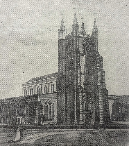
- The Surrey Evening Echo caption for the image is “The Parish Church Before the Great Fire in 1865”. This is somewhat ambiguous; it could mean that the image is from 1865, or it could be slight sloppiness in reporting the date of the fire. An accompanying image of the fire damage is simply captioned “The Ruins of the Church After the Fire”. For more information on the fire, see John Hickman’s Croydon Advertiser article or Brian Lancaster’s Consumed by Fire: The Destruction of Croydon Parish Church in 1867 and its Rebuild (CNHSS Proceedings Vol 19 Part 9, Sep 2016).
- Date and place of Mary and James’ wedding are taken from Church of England parish registers. The witnesses were Mary Brookes senior (John’s wife, mother of Mary junior), John Brookes, and [unreadable] Cox. Information on Mary’s inheritance is taken from John Brookes’ will, which describes Mary as “my daughter and only child” and mentions “my freehold Estate at Croydon and my share and interest in an Estate part freehold and part leasehold in the parish of St John Southwark”.
- John’s date, place, and age of death are taken from an announcement on page 4 of the 14 April 1835 Morning Chronicle. The announcement states that he died “in his 95th year”, meaning at the age of 94. His place of burial is taken from Church of England parish registers, which show his date of burial as 16 April 1835.
- Details and quotation are from my own transcription of John’s will. The “relatively small personal bequest” was a sum of £250 to be paid to “Catherine Sarah [something] Dale of Croydon [...] within three months after my decease free from Legacy Duty.” The phrase “notwithstanding any Coverture” in the excerpt quoted in the main article refers to the legal construction of coverture, by which a married woman was considered not to have any separate legal existence from her husband — she was a “feme [or femme] covert”, as opposed to a “feme/femme sole” who could own property and make contracts in her own name. John’s use of this phrase was likely intended to emphasise that the decision over his estate should be Mary’s alone.
As will be made clear later in the article, Mary did in fact take the option of expressing her decision via her will. The 1844 Tithe Award lists James Cox as owner and occupier of the Broad Green Place estate, but as explained here, he wasn’t actually the owner.
The question of who did legally own the land after John died and before Mary’s will was proved is an interesting one, and I don’t have an answer to it. There was no central registration of land at this point (the first attempt to make this compulsory came two decades later with the Land Registry Act 1862), and as Hampshire county archivist David Rymill explains on the East Meon History website, “I have sometimes wondered, and never quite worked out, whether the people who compiled tithe awards were given much advice as to who they were to call the landowner and who the occupier – given that a single piece of land can easily have multiple people who might be called owners and occupiers, once one gets into mortgaging, sub-letting and so on”. Perhaps James was listed as the owner of Broad Green Place simply because as Mary’s husband he was the closest possible approximation to a legal owner.
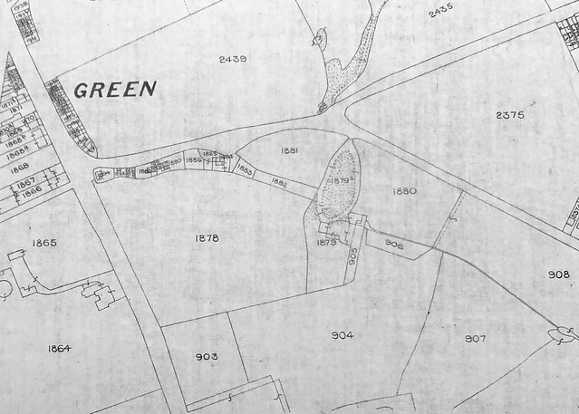
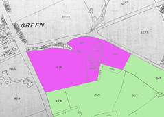
The boundary between James’ plots 1879/1879a/1880 and Richard’s plots 905/906 is not entirely obvious, as this map does not clearly distinguish between lines indicating plot boundaries and lines indicating fences and buildings. However, 905 and 906 are listed in the award as “Garden” and “Garden and orchard”, respectively, with no mention of buildings, while 1879 and 1879a are “house / out offices / yard / gdn [garden] & pt [part] of lawn” and “carriage drive / outbuildings & pt of lawn” respectively, which I believe implies the division I show in the highlighted excerpt included here.
I did try working out the boundaries by counting pixels in GIMP and using that to compare areas on the map to the areas given in the Award, but unfortunately the map isn’t quite accurate enough — the ratios vary so much that the inclusion and exclusion of the areas I’m unsure about are both quite plausible.
- It’s not clear why the 1847 map and 1850 directory use the spelling “Brook House” rather than “Brooke House”. James’ date and age of death are taken from an announcement on the front page of the 11 January 1862 Croydon Chronicle, which describes him as being in “the 88th year of his age”, which almost certainly means “aged 87”. Croydon in the Past states on page 69 that James was 88 when he died, but the 1861 census gives his age as 86, meaning he couldn’t have been 88 when he died less than a year later.
- Mary’s date of death is taken from her entry in the National Probate Calendar, and her age at death from the Croydon parish record of her burial. Quotations are from my own transcription of her will.
- Mary’s age and date of death are taken from a notice on the front page of the 17 July 1884 Times, which also notes that she was the eldest daughter of the family. Eliza’s age and date of death, as well as the total value of her estate, are taken from her entry in the National Probate Calendar. According to the Croydon parish record of Eliza’s baptism, she was born on 27 January 1808.
- Quotations regarding items put up for auction are taken from an advert on the front page of the 1 April 1899 Croydon Guardian, which states that the auction was to take place on 11 April. Quotation regarding the “Pale Messenger” (i.e. death personified) is taken from “The Argus Letters” on page 5 of the 8 April 1899 Croydon Advertiser.
Quotations regarding the cricket rumour are taken from “The Argus Letters” on page 5 of the 15 April 1899 Croydon Advertiser. This rumour may have had its origin in a letter published a handful of years earlier on page 6 of the 3 September 1892 Croydon Guardian, stating that “Broad-green-place, if at any time available, would be the very spot” for a “good Croydon Cricket and Athletic club and ground”. The writer suggested that “The house could be used as a club house, a pavilion be erected, and the whole property enclosed. [...] All our principal matches could be played there, and a Croydon cricket week, a la Canterbury, could be established.” One does wonder what Eliza, who was still alive and living in “The house” at this point, might have made of this.
Sale price and auction date of the Broad Green Place estate are taken from a report on page 5 of the 1 July 1899 Croydon Chronicle (“Record property sale by Messrs. Robt. W. Fuller, Moon and Fuller”).
- Quotation taken from an advert on the front page of the 6 May 1899 Croydon Advertiser.
Quotations taken from an advert on the front page of the 7 April 1900 Croydon Chronicle. The advert states that the building land is “at the junction of St. James’-road and Windmill-road, having a total frontage of about 284 feet [87 metres].” According to Raymond Wheeler’s book Norbury, Thornton Heath and Broad Green (p. 62), this site was actually used to construct St Michael’s and All Angels Church School, which opened in 1908 and continued in operation until 1976. (At the time of writing, the building is used as Baitus Subhan Mosque.)
The figure of 300 houses seems to have been fairly accurate. Using the abovementioned 1954 map to count the houses on each side of Nova Road and Hathaway Road, those on the south side of St James’s Road up to the “Ruin” (allowing for the fact that there was housing on the western end before the breakup of the estate), and those on the north side of Kidderminster Road (excluding the handful that were there already), plus two flats in each of the buildings of Royal Parade, I make it 285 new properties. The Kidderminster Road houses were not technically part of the Broad Green Place estate as such, but according to Aileen Turner’s unpublished History of Broad Green (p. 500, available in ring binders at the Museum of Croydon) they “or at least the ground” were “Cox property because when the Oakfield Estate was broken up in 1865 the Coxes either bought up the boundary land to preserve their privacy or developed it themselves”. (The History of Broad Green does not generally cite references, but in this case does state that the information is from sales particulars.)
Ward’s 1901 directory (the data for which were finalised late the previous year) lists Nova Road “From London Road to Kidderminster Road. No houses” and Hathaway Road “From London Road to St. James’ Road. No houses”, though “Fourteen houses building” are noted on the north side of Kidderminster Road. Later editions show that building had begun on Nova Road by the end of 1901 and on Hathaway Road by the end of 1902, and that by the end of 1908 the situation was pretty much as shown on the 1954 Ordnance Survey map.
Although the reason for Nova Road’s name seems fairly clear if unimaginative — it was a “new” road — I haven’t been able to find out why Hathaway Road was so-named. The minutes of Croydon Council’s Roads Committee meeting held on 19 September 1899 include a report from the Road Surveyor stating that “I beg to submit plans for Dassett Road (London Road to St. James’ Road) and Nova Road (London Road to Kidderminster Road), by Bayliss, Pearce & Co., on behalf of Charles Bentley, 181, Queen Victoria Street.” Clearly Dassett Road was the originally-intended name for Hathaway Road. Charles Bentley is also mentioned (as Charles Joseph Bentley) as having issued leases for property on Nova Road and St James’s Road in the conditions of sale for these properties held in the Museum of Croydon loose sales particulars collection (ref H+R 1717). It seems possible that Charles was the one who bought the Broad Green Place estate, or might have been acting for a company that did.
- Quotations taken from an advert on the front page of the 16 June 1900 Croydon Chronicle, reproduced here. I’m only aware of one photo showing Broad Green Place before its demolition; this photo is taken from the direction of St James’s Road, and appears on page 9 of Croydon: The Story of a Hundred Years (edited by John Gent) and page 61 of Raymond Wheeler’s Norbury, Thornton Heath and Broad Green. The former of these states that the photo was taken “about 1900”.
- Historical planning records held by Croydon Council include an index card (ref 11731) reading: “Royal Parade / London Road / 26 Houses & Shops / A H Batley / July 18 1901”. (A later annotation in different handwriting reads: “206–272 / (4 cards)”.) The microfiche records corresponding to this reference number were missing from the Planning Department’s filing cabinets when I attempted to consult them in January 2019, but cross-checking the records relating to two other index cards from around the same date (ref 11700 dated 13 October 1902 and ref 13233 dated 11 January 1904) showed that the dates given on the cards are the dates that the plans were deposited with the Council. Regarding A H Batley’s title, card 11700 also contains the same name, and the records refer to this person as “Mr Batley”.
- I am speculating slightly regarding the architect in charge, but certainly the original planning index card for 1 Royal Parade (ref 11700) includes the text “H. Bonner / Architect”, and the Museum of Croydon holds a colour lithograph by Horace T Bonner, A.R.I.B.A., “Archt”, showing an artist’s impression of Royal Parade (ref M/1996/1896, reproduced here). Horace’s full middle name is taken from his entry in the Directory of British Architects 1834–1914 (ed. Antonia Brodie), which also states that he was “In practice in Lewisham from 1876.” I’m not sure who A H Batley was; he may have been the developer who bought the estate, or he may have been some sort of agent.
Quotation regarding architectural style and information on back entrances are taken from Croydon Council’s Supplementary Planning Guidance for the London Road (Broad Green) Local Area of Special Character (adopted 16 July 1996) (PDF). Ward’s 1903 directory makes no mention of Royal Mansions, but lists some persons who must be private occupiers on the “top floor” or “first floor” of various Royal Parade addresses. The 1904 edition lists shops and flats separately, with the latter under the subheading “Royal Mansions (over Royal Parade)”.
According to the abovementioned Supplementary Planning Guidance, the parade was “named in honour of the coronation of King Edward VII” (p. 3), but no reference is given for this, I haven’t been able to independently verify it, and Sanne Roberts of Croydon Council tells me that they have no records of the research done to compile the report and everyone involved has now left (via email, 7 October 2019).
- See for example page 5 of the 16 August 1902 Croydon Guardian. In addition to this, there is a surviving moulding on the side wall of number 238 with the date “1902” (see my photo and a close-up).
- Quotations and information taken from an article on page 2 of the 27 September 1902 Croydon Guardian (“Croydon County Council”). Councillor Strank seems not to have made a formal motion to refer the matter back to the Roads Committee, and the article ends by stating that the Committee’s report was “adopted”.
- Ward’s 1903 directory, which according to its preface was “kept corrected down to the day of going to press, which is usually the last week in November [the previous year]” lists occupants at 3, 10, 11, 12, 13, 14, 15, 16, 21, 22, 23, 24, and 26 Royal Parade. The others are listed as “Unoccupied”, but an advert on page 4 of the 15 November 1902 Croydon Chronicle places Clark & Co, cycle & motor engineers, at number 8, and an advertorial on page 5 of the 20 December 1902 Croydon Chronicle describes the Royal Parade Cigar Stores, “opened in London road during the present week by Mr. Harrop”, and the American Candy Store, “A few door’s [sic] from Mr. Harrop’s shop”. Details of businesses as of the close of the first decade of the 20th century are taken from Ward’s 1910 directory.