Usually in these articles I cover a single building from construction to the present day. However, in my investigation of 21 London Road, I found out so much information that I’m splitting it into two parts. Here, I’ll discuss issues around the construction of the building, and next time I’ll describe its inhabitants over the years.
The question of architectural style
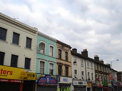
Looking at this area of London Road today, one could be forgiven for assuming that number 21 was built as part of a block with numbers 23–29. These properties are architecturally similar to each other, all of the same height, and clearly different from their taller neighbours just to the left.
However, the historical evidence indicates that in fact number 21 was constructed at the same time as the very different-looking buildings at numbers 13–19, while numbers 23 upwards came later. Croydon street directories show businesses at 13–21 from 1864 onwards, and 23–29 don’t appear until 1872.[1] In addition, 13–21 appear on the 1868 Town Plans, but 23–29 are absent; the land they would later occupy is shown as the grounds of the Congregational Chapel.
It thus seems clear that number 21 was built in the mid-1860s, around the same time as numbers 13–19. The question then arises: why was it built in such a different style?
1820s–1820s: Inclosure, the Caldcleughs, sale of land
One potential reason could be that it was built by — or for — a different person. The land along the west side of London Road at this time was a patchwork of small plots owned by different people. This situation stemmed from an 1835 sale of land that had previously been an area of common land known as Parsons Mead (which later gave its name to the road known as Parsons Mead today).
The Parsons Mead Inclosure Act of 1823 led to this land passing into the hands of the Caldcleugh family, who owned Broad Green House a little further up the road. The Caldcleughs didn’t develop the land themselves, but after the death of Elizabeth Caldcleugh in February 1835, it was split up into several plots and sold at auction.[2] The plots fronting on London Road up as far as modern-day Chatfield Road ended up being owned by a total of eleven different people.[3]
1835–1850s: A plot of land, but no buildings
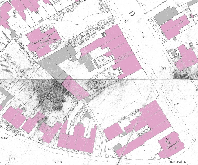
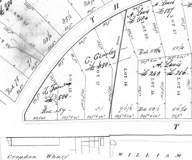
However, the land on which 13–19 and 21 were built had the same owner until at least 1858, just 5 or 6 years before the buildings were constructed, and I’ve found no evidence of it changing hands in those few years. Croydon Local Studies library has a map from the particulars for the 1835 sale (shown above) with the names of the purchasers written on it, so it’s clear that the first 178 feet 6 inches going north from Parsons Mead was bought by James Turner, and the next 161 feet by Charles Crowley.[5] A comparison of these distances with distances measured on more recent maps strongly suggests that numbers 1–11 were built on the land purchased by James Turner[6] and numbers 13-29 on the land purchased by Charles Crowley.[7]
”")
Although it is of course possible that Mr Crowley split his land up further and sold it on to different parties, particulars from an 1858 sale of the same land (shown above) make it clear that the land remained a single lot at that date, which doesn’t leave much time for further selling-on before 1864 — and indeed, a search for relevant sales particulars in the computerised catalogue at Croydon Local Studies Library turned up nothing.[8]
1860s: Construction of numbers 13–21, and Henry Reed moves in to number 21
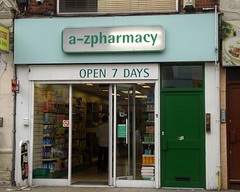
Given this, it seems likely that the builder of number 21 was the same as the builder of numbers 13–19, and the difference in style was due to the budget of the intended purchaser. As I’ve previously mentioned, numbers 13–19 were initially owned by Benjamin Culpeck, a prosperous carriage-builder. The first owner of number 21, however, was Henry Reed, a pastrycook and confectioner who set up business there around 1864.[9] Perhaps Mr Reed simply couldn’t afford to have his property built to the same standards as those of his neighbours.

1860s: The general state of London Road
In the mid-1860s, Henry Reed’s shop marked the northern boundary of the commercial development running up London Road from West Croydon Station. From here up to the junction with Sumner Road, all of the buildings on both sides of London Road were private residences, aside from the abovementioned Congregational Chapel and the ladies’ school run by the Misses Jeffcott (which was roughly where Savemore Spicy Foods is today).[10] Beyond Sumner Road was Broad Green, which already had its own little cluster of businesses. In the years to come, development would spread up London Road to meet Broad Green, until as at the present day there was no obvious boundary between them.
[In part 2: A century of baking, a brief interlude of fish and chips, and Croydon’s most confusingly-named takeaway.]
Thanks to: Henry Braun, for architectural discussions; Alex Brett, for assistance with stitching images; all at the Croydon Local Studies Library; and my beta-reader Flash.
Footnotes and references
- Directories consulted: Gray’s 1851, Gray’s 1853, Gray and Warren 1859, Gray and Warren 1861–62, Simpson’s 1864, Warren’s 1865–66, Warren’s 1869, Wilkins’ 1872–3.
- For more on the Parson’s Mead Inclosure Act, see my article on 145 London Road. I’ll discuss the Caldcleughs at greater length in my article on Broad Green House. See also pages 31–33 of Urban Development and Redevelopment in Croydon 1835–1940, Ron Cox, PhD thesis, Leicester, 1970.
- Cross-referencing the handwritten notations on a copy of the particulars for the 1835 sale (viewed at Croydon Local Studies Library, ref BA268) with the 1839 New Valuation of Croydon Parish (shelfmark fS70 (352) at Croydon Local Studies library) and the 1844 Tithe Award (also viewed at Croydon Local Studies Library) shows that the people who purchased the land up as far as Chatfield Road were James Turner, Charles Crowley (in two disjoint parcels), Arthur Lewis, William Inkpen, Samuel Bendry Brookes (or Brooks) (in two disjoint parcels), Henry Bance, John Budgen, John Blake, somebody Owens, Henry Overton, and J Barratt. (I related the 1835 map to modern-day roads with OpenStreetMap data visualised as CloudMade tiles and overlaid on the map using Inkscape.)
- West Croydon Station opened in 1839, four years after this map was made. For more on the Croydon Canal, see my article on West Croydon Station in the 1800s.
- The map actually only has initials, not full first names; see footnote [3] for where I got the full names from. The 1835 sales particulars are available bound in the Harold Williams volumes at the Croydon Local Studies Library, and also loose under reference BA268.
- I make the distance between the south boundary of number 1 and the south boundary of number 13 to be approximately 159 feet 1 inch on the 1868 Town Plans (97mm, i.e. 48.5 metres at the scale of 1:500) and 160 feet 9 inches on the August 2001 Goad plan (49mm, i.e. 49 metres at the scale of 1:1000). The small discrepancy between the 1868 Town Plans and the August 2001 Goad plan here is probably because this area of London Road appears on two separate sheets in the Town Plans, making it hard to measure properly. The discrepancy between these distances and the 178 feet 6 inches stated for James Turner’s 1835 purchase is harder to explain — where are the missing 18 feet? My feeling is that they must lie under the side road (now Derby Road); there’s a very plausible-looking bend at this end of Derby Road, starting further up than would correspond to the small portion nipped off the corner of James Turner’s plot on the 1835 map. Henry Braun concurs: “Even without going out with a tape measure it's clear that the square Fox and Hounds building wasn't built right up to the SW corner of the original plot 19: there's only a depth of about 14 feet there from the line of the road, while the F&H is at least 30 feet deep and set back another 6 or 8 feet from the original road edge” (online discussion, July 2013). It thus seems that the London Road end of Derby Road was moved slightly to the north at some point, though I’ve not found any documentary evidence of this. The best theory I’ve heard as to why this might have happened is one proposed by bob walker, specifically that the road was moved in order to make room for the 1847 extension of the railway down to Epsom.
- By my measurements, the distance between the south boundary of number 13 and the south boundary of number 31 is 160 feet 7 inches on the 1868 Town Plans (98.5mm, i.e. 49.25 metres at the scale of 1:500) and 160 feet 9 inches on the August 2001 Goad plan (49mm, i.e. 49 metres at the scale of 1:1000). This is pleasingly close to the 161 feet listed for C Crowley’s purchase on the 1835 sales particulars and the full lot on the 1858 sales particulars.
- A search on ‘London Road’ for the years 1858 to 1864 inclusive turned up nothing relevant (aside from the 1858 sale discussed in the main article), and neither did a search for ‘Turnpike’ (London Road was once known as the Turnpike Road).
- Simpson’s 1864 street directory lists H Reed, pastrycook and confectioner, at 11 London Road, which was renumbered to 21 London Road in 1890, and this is confirmed by a listing for “Hy Reed” in the June 1864 Poor Rate Book (“Hy” was an abbreviation for “Henry”). The Poor Rate Book also states that the property was owned, rather than leased, by Reed.
- Occupants on both sides of road as listed in Simpson’s 1864 directory. The northernmost commercial property on the east side of the road was Meredith & Co.’s corn and coal store, which I believe to have been where number 22 is today.